
Exhibition
Urban Cartographies of Maranhão
14 June to 14 July 2023
The Ministry of Culture and Vale present Urban Cartographies of Maranhão, a timeline shown on maps of Maranhão in different periods, from the 15th to the 20th century.
From the discovery of the new territory through rivers and seas, indigenous villages and sandbanks, through the layout of the village designed by the Portuguese and ending with the process of urban expansion of the city. It is curated by Grete Pflueger and Rosilan Garrido.
The first maps were made by the Greeks and the Arabs and were important tools in exploratory expeditions to discover new continents around the world. For a long time they were the subject of knowledge, power, and disputes in the cycle of the great navigations of the 15th century. The oldest in Brazil correspond to the period of the arrival of European expeditions and were used as a tool for the knowledge and disputes of the ancestral territories of the indigenous tribes by the French, Portuguese, and Dutch.
The section defined in this exhibition demonstrates the cartography prepared in different periods between the 15th and 20th centuries, the first period of knowledge of the territory, the rivers, the indigenous villages, the seas and sandbanks characteristic of the coast of Maranhão, followed by the time of urban maps with the layout of the town devised by the Portuguese, with the definition of the planning of streets and blocks and the location of the churches and convents and fortresses, and finally the time of the maps of the end of the colony and the beginning of the 20th century republic, with the process of urban expansion of the city.
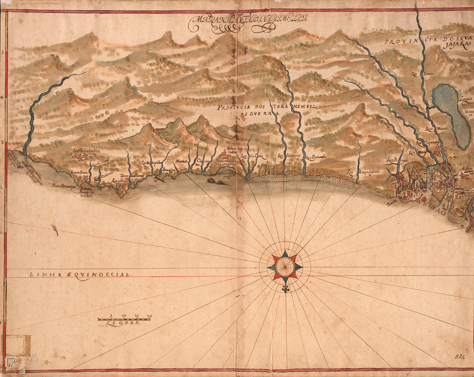
Among the numerous existing copies in the cartography of Maranhão, we highlight the Dutch map from 1641-44 from the book by Gaspar von Barleus and the Italian engraving by Andrea Orazi, from 1648, both originals can be found in the National Library of Rio de Janeiro. The Gaspar Barleus map represents the first records of our territory, which includes the urban layout left by the Portuguese chief engineer, Francisco Frias de Mesquita. In it, we see a citadel inside the walls, with the first official buildings: churches, the fort and command house of the territory -in the same place where the Palace of the Lions is located today-, the port and some geographical limits. Andrea Orazi’s engraving represents the Dutch occupation, with ships anchored from the tip of the sand to Praia Grande. It shows the city in its beginnings, with a church and small houses on top of the promontory, now Pedro II Square.
Other maps in this exhibition record the expansion of the city in subsequent years, such as the one in 1950, which shows a city of 150,000 inhabitants, still circumscribed to the center, but with the inclusion of new avenues such as Magalhães de Almeida, and Getúlio Vargas, and also the Caratatiua, São Francisco, Bandeira Tribuzi and Bacanga bridges.
In times of Google Earth, which expanded the visualization and notions of the world with the click of a cell phone, having access to the cartography of Maranhão in this exhibition is a delight for the eyes and the understanding of the difficulties faced by travelers in remote times, in addition to aggregating extremely useful information for scholars and the community in general. Some beautiful examples based on paths that constitute a poetic record of reality seen and idealized, without the rigour of mathematical data and Cartesian plans, stand out.
Grete Pflueger and Rosilan Garrido
São Luís
17th century
Geographic Maps
Small Atlas of Maranhão and Grão-Pará
Author: João Teixeira Albernaz I
National Library of Rio de Janeiro


18th century
Maps of the Urban Apogee

Torre do Tombo National Archive, Lisbon
Nineteenth century


Twentieth-century
Urban expansion processes

Author: Justo Jansen Ferreira | National Library of Rio de Janeiro


Map of the architectural styles of the buildings in the historic center | Author: Unidentified/UNESCO
Alcantara
18th century
Urban Formation Studies


Twentieth-century

Alcantara Urban Development Timeline
15th Century – Tapuitapera and Cumã Indigenous Villages
17th Century – Catechesis and Possession
1648 – Foundation of the Portuguese religious village of Santo Antônio de Alcántara
18th Century – Urban and Economic Apogee
1755 – Alcântara headquarters of Companhia Grão-Pará do Maranhão’s rural agro-cotton agro-exporting aristocracy, built by enslaved African peoples
18th to 20th Century – Economic Decline
1890 – 1950 – Decline
1948 – 1950 – Vargas Era – Vitorinism
1948 – State Prison in Alcántara – Exclusion
1950 – Listing of Alcantara by IPHAN
1965 – It was Sarney
1970 – Preservation plan of the architects Pedro and Dora Alcântara – IPHAN/RJ and the Unesco Mission
São Luís Urban Development Timeline
17th century
1612 – French “Foundation” of Saint Louis
1615-1618 – Portuguese urbanization of São Luís
1641-1644 – Dutch invasion
18th Century – Urban and Economic Apogee
1755 – Companhia Grão-Pará-Maranhão cotton exporter – Portuguese-Brazilian architectural complex built with the labor force of the African people
Nineteenth Century – Economic Decline
1890 – Abolition of slavery and changes in the cotton market.
1900 – Attempted industrialization – Fabric Factories
Twentieth-century
1936 – Otacílio Saboya Ribeiro’s beautification plan
1940 – Vargas Era – Hope in Babaçu and urban renewal in the center – São Luís – 120 thousand inhabitants
1958 – Ruy Mesquita’s expansion plan
1974 – IPHAN registration
1977 – Haroldo Tavares and Wit Olaf Prochnik’s expansion plan
1997 – Registration of the Historic Center by UNESCO as a World Heritage Site – São Luís – 1,200.00 inhabitants
21st century
2023 – Challenges of urban expansion and preservation of tangible and intangible heritage
URBAN CARTOGRAPHIES OF MARANHÃO
Curatorship
Grete Pflueger
Rosilan Garrido
Map Search
Larissa Machado
Artistic Coordination
Deyla Rabelo
Gabriel Gutierrez
Expography
Gabriel Gutierrez
Raimundo Tavares
Lighting
Calu Zabel
Visual Communication
Fábio Prata, Flávia Nalon (PS.2)
Production
Nat Maciel
Pablo Adriano
Samara Regina
Mounting
Diones Caldas
Fábio Nunes Pereira
Rafael Vasconcelos
Renan José
Impressions
Daniel Renault (Giclé Fine Art Print)
CENOTECHNICS
Pintura
Gilvan Brito
Woodworking
Dyoene Fração Ribeiro
Edson Diniz Moraes
Nerilton Fontoura Barbosa
Production
Nat Maciel
Pablo Adriano
Samara Regina
Mounting
Diones Caldas
Fábio Nunes Pereira
Rafael Vasconcelos
Renan José
Impressions
Daniel Renault (Giclé Fine Art Print)
CENOTECHNICS
Pintura
Gilvan Brito
Woodworking
Dyoene Fração Ribeiro
Edson Diniz Moraes
Nerilton Fontoura Barbosa
President
Eduardo Bartolomeo
Executive Vice President of Sustainability
Maria Luiza de Oliveira Pinto e Paiva
Strategic Council
Maria Luiza de Oliveira Pinto e Paiva (president)
Flávia Constant (vice-president)
Hugo Barreto
Octávio Bulcano
Executive Board
Hugo Barreto (CEO)
Luciana Gondim (Director)
Gisela Rosa (Director)
Sponsorships and Projects
Marize Mattos (Coordinator)
Direction
Gabriel Gutierrez
Steering Assistance
Deyla Rabelo
Coordination of the Educational Program
Ubiratã Trindade
Educators
Alcenilton Reis Junior
Amanda Everton
Maeleide Moraes Lopes
Educational Program Interns
Carlos Carvalho
Iago Aires
Jayde Reis
Lyssia Santos
Communication Coordination
Edízio Moura
Design
Ana Waléria
Production Coordination
Nat Maciel
Producers
Pablo Adriano Silva Santos
Samara Regina
Financial Coordination
Ana Beatris Silva (In Account)
Financial
Tayane Inojosa
Administrative
Ana Célia Freitas Santos
Reception
Adiel Lopes
Jaqueline Ponçadilha
Janitorial
Fábio Rabelo
Kaciane Costa Marques
Luzineth Nascimento Rodrigues
Maintenance
Yves Motta (general supervision)
Gilvan Britto
Jozenilson Leal
Safety
Charles Rodrigues
Izaías Souza Silva
Raimundo Bastos
Raimundo Vilaça